Updated January 2006

Bagan: location map. The city was at its most active between the 11th and early 14th Centuries AD, but it remained in use as a religious centre after the Burmese capital moved north to Sagaing, Ava and Mandalay. It is now a popular site with Buddhist pilgrims, and with tourists from overseas, who often arrive there by way of a day's ferry trip down the Irrawaddy river from Mandalay.
This wonderful etching is Sir Henry Yule's impression of Bagan, from his 1904 book on Marco Polo. The Italian adventurer had described in his memoirs how the Mongol Army of Kublai Khan fought a war with the king of "Mien", the Chinese name at the time for the kingdom based on Bagan.
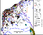
This map shows all of Bagan's remaining buildings.
It was created on MapInfo, which is a GIS (Geographic Information Systems)
program. You need to look at the big version to get an idea of the scale of
construction. Some of the buildings are hard to distinguish even at the larger
scale, because there are so many of them, but the map gives an idea of the
layout of the city. Note the dense clusters of buildings to the southeast of the
main clump of monuments (the top of the map is north). These were the
later "suburbs" of Pagan, thick with monasteries. I suggest that
overcommitment to building and particularly to the maintenance of buildings, as
seen in this pattern of nodalisation of the city, overstretched its
economic and communication resources, and left it vulnerable to stress.
 The Ananda temple at Bagan. This huge temple
is a major Buddhist pilgrimage spot. It is located just east of the walled core
of the city. On the top right of the picture you can just see Tanggyi Taung, a
mountaintop stupa, or pagoda, on the other side of the Irrawaddy River.
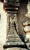 Detail of stucco decoration on a temple.
Stucco is a sand and lime plaster that is laid on to a surface and moulded or
carved while damp.
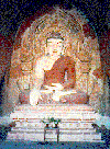 Buddha image inside a temple at Bagan. This
is a painted plaster statue, made on a brick base. You can see the remains of
wall paintings of Buddhist scenes in the background.
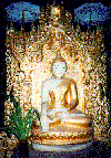 A more modern Buddha image, made from marble.
Note the highly decorative setting. Marble is mined north of Bagan, around
Mandalay, and that city has a suburb where the marble is used to manufacture
Buddha images.
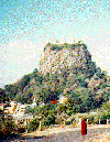 Mount Popa, a volcanic plug about 60 kilometres
southeast of Bagan. There is a temple complex on top, reached by a winding
staircase around the side of the mountain. The "brother and sister nats"- spirit
protectors of Bagan- are supposed to live here. There are references to Mount
Popa from the Bagan era, but there appears to be no formal dating
available. The monk in the picture was walking as if in slow motion, being
mindful every step he took- a tradition among monks in this area.
If you
would like a great big (1.4 MB) bitmap version of this picture to display on
your desktop just click here to
view or download it.
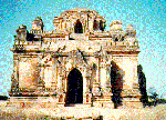 A temple at Bagan. Some temples are built on a solid
core, with corridors encircling the central mass, while others have a vaulted
centre section more as you would expect from a modern building. The builders at
Bagan knew how to use the "true" arch, which was not used at the time in other
parts of Southeast Asia.

Ruined temple and monastery complexes at
Minnanthu, about 4 kilometres back from the river at Bagan- this was one of
several "suburbs" of the medieval city. The buildings and their walled
enclosures took up a lot of space. Bagan is quite dry, and there were few local
irrigated rice fields in medieval times. But the city "owned" about
250,000 hectares of irrigated land up and down the Irrawaddy, and rice was
presumably sent to Bagan along the river, for distances of up to 100 kilometres.
Much of this outlying land was officially dedicated to the upkeep of various
temples and monasteries. People were also permanently dedicated as what are
often called "temple slaves", although "slave" is not really an accurate term,
as most of these devoutly religious people appear to have considered it an
honour. Some families in Bagan still trace their ancestry back to these original
servants of Buddhism. Dedications of land, people or silver were
written on foundation stones, many of which still exist and are kept either at a
museum in Pagan or at their original sites.
 A moulded clay votary tablet, left as an offering at a
temple at Bagan, probably between the 11th and 13th Centuries AD. Note the
multiple images of the Buddha.
 Bagan also has some stunning treasures, such as this
votary plaque in beaten gold. This is in the museum at Bagan.

An apparently modern stupa upriver from
Bagan. Note the rubble along the bank, either from flood damage, or laid
there in an attempt to reduce flood damage. A stupa is a burial mound. In the
early history of Buddhism, particularly during the reign of the Indian Buddhist
King Asoka, remains of the Buddha were believed to have been transported
far and wide throughout the Buddhist world, and encased in stupas (which are
also called cedi, depending whether you use the Pali or Sanskrit based name).
These remains could have been ashes from cremation, or remnants of items
associated with the Buddha. The result is that a stupa can be either a monument
that acts as a reminder of Buddha ( possibly containing a holy relic), or
an actual burial monument for the ashes of an individual Buddhist.
 The city wall and moat in the core of Bagan. The wall
today only has three sides. Its western side may have been washed away by
the river either during or after medieval times at Bagan.
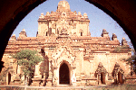 A temple framed by the archway of its courtyard
gate. These temples are quite cool inside despite Burma's hot climate.
They are made from brick, plastered on the inside and outside. The bricks are
set in a clay mortar, not with cement.

These buildings are within the city walls of Old
Bagan. The stupa in the centre is covered with green glazed tiles. The steel
bands are to support it because it suffered stress following a severe earthquake
that hit Pagan in 1975 and damaged many buildings. Since this picture was taken,
its top has been repaired, and it now has a traditional pointed cap on it (see
the next picture). The white temple in the background is in modern use. It is
kept whitewashed by a temple committee responsible for its upkeep. If a building
is painted white, this is usually an indication that it is active as a religious
centre. The unpainted brick temples are looked after by the Archaeology
Department at Pagan. Some observers have commented that the locals in Burma only
seem to want to go to the white temples, while the tourists only seem to want to
go to the brown ones! Visitors are expected to show respect, including
removing their shoes when they go inside, whether a temple is in active
use or not.
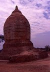 This is the restored "ear ornament" pagoda,
so-called because it is said to have been modelled on the earring of one of the
nobles of the Bagan period.
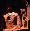 This ruined temple, whose roof is gone,
contains a brick and plaster image with a small cavity in the chest. If you look
closely (click on the image for a larger version) you can see that the cavity
was specially made, with a base of brick or stone. This cavity may originally
have contained relics, small Buddha images or other treasures, sealed inside the
image. The treasure has long since proven to be a temptation to some passer-by.
It was not necessarily robbed in modern times- Pagan had several centuries
without much supervision of its buildings, particularly those in out of the way
places like this temple is. It you ever visit Pagan, this is a short walk
northeast of the Dhammayazika stupa. The photograph was taken around noon, so
the image inside the roofless temple could be illuminated by sunlight. Remember
that this picture, like all on these pages, is copyright. That means you can use
it for an essay or university paper if you credit it in your bibliography, but
it cannot be used for commercial purposes like a book, map or brochure, without
permission.
To contact me about anything on this site, copy the line in red text into your mail program "to" line. This procedure is an attempt to reduce SPAM.
hudson@mail.usyd.edu.au
© Bob Hudson, 1997-2006